When most people think of maps on websites, they think of a generic Google Maps embed – the kind that drops in with minimal customisation and does the job of showing “where we are”. But we know maps can be so much more than that.
Maps can express complex data, tell a story, and create a more engaging experience for your users. They can also be customised to fit your brand and website design, integrate seamlessly with your content management system, and avoid the limitations of third-party providers.
Why Our Approach Stands Out
Whether we’re using MapLibre, Leaflet.js, Google Maps, or custom imagery, our work is driven by:
- Technical flexibility
Choosing the right platform for the project, not just defaulting to the familiar. - Data-driven enhancement
Enriching maps with relevant overlays, routes, charts, and geospatial information. - Brand integration
Ensuring maps feel like part of the site, not a bolted-on widget. - Performance awareness
Delivering only the level of interactivity needed, keeping pages fast.
Maps in Action
Our web team has worked on projects where maps aren’t just functional – they’re intelligent, branded, and tailored to the context of the site. Here are a few examples of how we’ve helped clients go further with their map integrations:
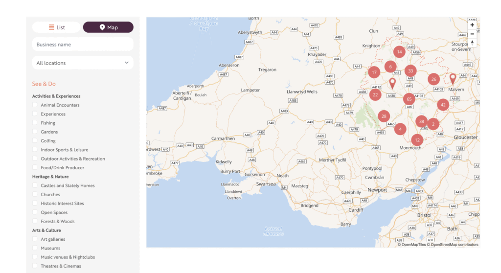
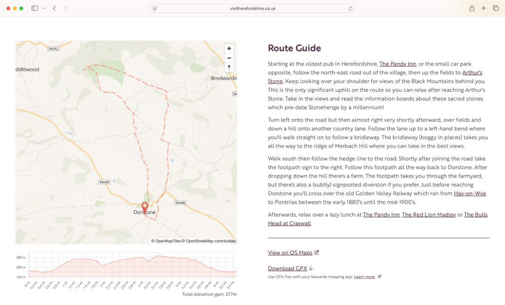
Visit Herefordshire: A Custom Map Server for Total Control
For Visit Herefordshire, we set up a dedicated map server so the client had complete control over map styling, data sources, and costs – avoiding the uncertainty of third-party variable prices that spike with website traffic.
Using MapLibre, we designed maps that fitted the aesthetic of the website and removed unwanted third-party branding. We also enriched the maps with highly targeted data:
- County border overlay using official gov.uk data.
- Variable map detail – higher fidelity inside Herefordshire (street names, building outlines, rural detail), and more minimal styling outside the county.
- Context-aware features – walking routes show contour lines sourced from Ordnance Survey Open Data, visible only when zoomed in.
- Interactive business portal – business owners can plot their location using postcode search, dragging a pinpoint, or entering a What3Words phrase, all of which are pupose-developed for intuitive use.
To supplement walking maps, we also include features like route overlays, elevation charts, and GPX downloads to provide a comprehensive tool for outdoor enthusiasts.
This approach means the map experience is unique to the site and audience, while remaining fast, cost-effective, and free from unnecessary clutter.
Frank P Matthews: A Themed, Data-Rich Google Map
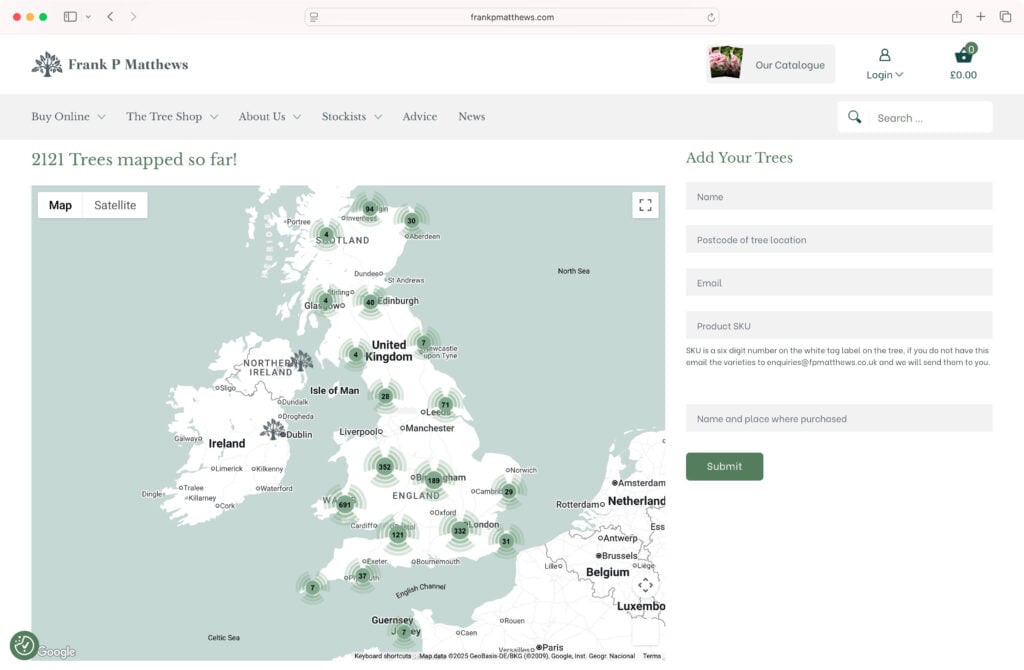
While we often recommend alternatives to Google Maps, sometimes it’s the right tool for the job … especially if it’s customised correctly.
For Frank P Matthews’ Tree Map, we implemented a heavily themed Google Map that matched the brand. We also grouped markers to keep the view clean at wider zoom levels, preventing overwhelming clusters of pins. The result is an on-brand map that works as both a marketing tool and an interactive catalogue of their trees.
Ambrey: The Power of Static Maps
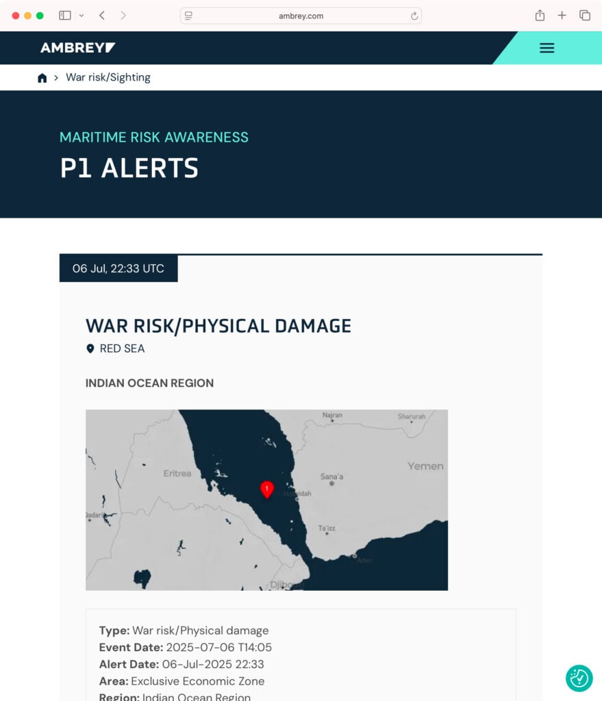
Not all maps need to be interactive to be effective. For Ambrey, we developed a system that generates static map images to illustrate specific events on their website, such as war risk sightings. This solution is particularly valuable as it allows for the inclusion of a map without the overheads associated with loading a fully interactive one.
The real intelligence behind this integration lies in its automation. The system automatically takes longitude and latitude data from an in-house API at Ambrey and generates a static image utilising MapBox. It even includes clever functionality that detects the amount of ocean visible in the image and automatically zooms out and regenerates the map if the amount of ocean is too high. This ensures every map is perfectly framed and highly relevant without any manual intervention.
Need More Than Just a Pin?
If your website needs maps that go beyond the basics – whether it’s for tourism, retail, data visualisation, or internal tools – we can help. Our team combines technical skill with design flair to produce maps that look great, perform well, and serve a real purpose.
Contact us to discuss how we can bring your mapping project to life.